 Tools
Tools Tools
Tools


Jung, M.  ORCID: https://orcid.org/0000-0002-7569-1390
(2025).
Land depression based imprints of historic steppe habitats in the Seewinkel region, Austria.
10.5281/zenodo.16790523.
ORCID: https://orcid.org/0000-0002-7569-1390
(2025).
Land depression based imprints of historic steppe habitats in the Seewinkel region, Austria.
10.5281/zenodo.16790523.
![[thumbnail of Data set]](https://pure.iiasa.ac.at/style/images/fileicons/other.png "Data set") |
Other (Data set)
depression_seewinkel_cleaned_version1.gpkg - Published Version Available under License Creative Commons Attribution. Download (56MB) |
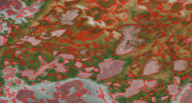
![[thumbnail of screenshot.png]](https://pure.iiasa.ac.at/id/eprint/20821/2/screenshot.png "screenshot.png")  Preview |
Image
screenshot.png - Supplemental Material Available under License Creative Commons Attribution. Download (10MB) | Preview |
Abstract
Pannonic salt steppes and salt marshes (EUNIS code 1530) or 'Sodapans' are among the rarest habitat types in Europe. They have historically been common in the Seewinkel region of Burgenland, Austria. Because of centuries of human modification of the landscapes only few Sodapans remain to this date. However 'imprints' of historic habitat extent can still persist and be visible from high-resolution digital terrain models (DTMs). Knowledge of such original extents can be useful particular in the context of habitat restoration and specifically rewetting, although many of known sites have been lost since centuries and might not be restorable.
In this upload a characteriziation of small-scale depressions in a high-resolution DTM are made through a flood-fill algorithm (following an approach by Wu et al. 2019), cleaned and pre-processed to a spatial vector format. The result is presented in vector format containing small-scale depressions that might (!) indicate historic distribution of Sodapans in the Seewinkel.
Data:
Derived from a Digital Elevation Model (DTM) obtained from the Austrian state of Burgenland (released under CC-BY 4.0), created from a 5 m (source).
Format:
Spatial GeoPackage (similar as shapefile). Can be opened in most Geographic Information System software such as QGIS or ArcGIS.
Data columns are included that describe a unique id for each identified patch, the indicated area (in m²) and summary statistics (min, max, median, mean) of the local depression depth relative to the surroundings.
Usage notes:
- The dataset shows localized terrain depressions which might inidcate a historical or current sodapan. However the landscape in the Seewinkel has been heavily modified since centuries and even terrain imprints are not necessarily an indicator of any natural feature.
- Care should thus be taken when using this dataset for further analysis. The author takes no responsibility for errors or misrepresentations. The data is released as such, although further improvements and updates are possible.
- Terrain depressions smaller than 5000 m² have been ignored.
- Some land depressions likely related to construction activities (e.g. building of houses) or artifical water surfaces or sand pits have been manually removed.
| Item Type: | Data |
|---|---|
| Research Programs: | Biodiversity and Natural Resources (BNR) Biodiversity and Natural Resources (BNR) > Biodiversity, Ecology, and Conservation (BEC) |
| Related URLs: | |
| Depositing User: | Michaela Rossini |
| Date Deposited: | 22 Sep 2025 13:29 |
| Last Modified: | 22 Sep 2025 13:29 |
| URI: | https://pure.iiasa.ac.at/20821 |
Actions (login required)
 |
View Item |